Battle of Identities at the India-Bangladesh Border
The steady influx of Bangladeshi migrants in India’s north-eastern state of Assam led to major ethnic backlash in the late 1970s. In reaction, the Indian government decided to fence its border with Bangladesh, which, ever since, has become the site of national identity politics and contestation over irregular migrants.
India and Bangladesh share a 4096.7-kilometre-long international border along the Indian states of West Bengal, Assam, Meghalaya, Tripura and Mizoram. Historically, the border resulted from the 1947 Radcliffe Award of the Bengal Boundary Commission that divided the British-ruled state of Bengal and people historically connected by customs, kinship and trade, into the sovereign states of India and East Pakistan. Subsequently, the Assam Accord of 1985, which accommodated the claims of the sub-national Assam Movement to keep out irregular migrants, prompted the construction of a fence by India along the India-Bangladesh border.
A CONTESTED HISTORY
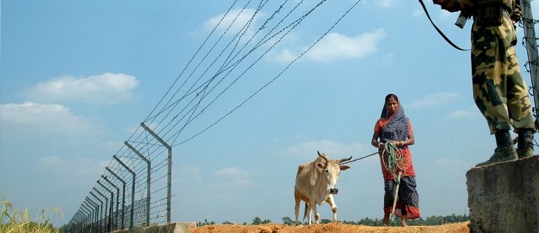
Raised on the edifice of multi-scalar politics of control centring on the issue of curbing irregular migration from Bangladesh to Assam, the fence now covers more than 3,000 kilometres running through agricultural lands, hills and forests. For about 1,000 kilometres however, the border meanders along stretches of shifting river courses, rendering fencing impossible. The border fence, at times electrified, at times consisting of parallel barbed-wire fences, has transformed the Bengal borderland into a high-security surveillance zone. It is punctuated by countless border outposts and watchtowers, patrolled 24 hours a day by India’s Border Security Force (BSF), and sustained by a host of intelligence agents.
The border fence stands 150 yards inside Indian territory, often on agricultural fields of farmers who need to identify themselves daily at the border gates to go to work. A high volume of informal trade, mostly cattle and goods of everyday use, takes place across the India-Bangladesh land border, frequently with the tacit consent of anti-smuggling enforcement agencies. Playing an endless cat-and-mouse game, the Indian BSF border guards run behind “infiltrators” or “smugglers”, and sometimes even goats and hens that stray from one rural landholding in Bangladesh to the adjoining one in India. Instances of major violence and shootings by BSF guards of “infiltrators” have caused popular uproar. Migrants, traders, smugglers and locals visiting family or friends nevertheless subvert the border on a daily basis with the support of borderland people on both sides.
GOVERNMENTALITY OF MIGRATION
A combination of political and economic factors, including local insurrections, religious persecution, social insecurity, governmental apathy and environmental issues, sustains the steady flow of irregular migrants from Bangladesh. Though no exact figures are available, Indian government sources estimate the number of “illegal Bangladeshi migrants” in India at 15 to 20 million. The migrants often work in brick kilns, the construction industry, factories and private households in urban centres like Delhi, Mumbai or Bengaluru. The Indian narrative of infiltration remains silent on the employment of unauthorised Bangladeshi immigrants by Indian citizens. The Bangladesh government, for its part, has remained in denial of the flow of its citizens to India, limiting itself to stripping the migrants of their Bangladeshi citizenship and ignoring their existence.
FENCING FOR VOTES
 Guards at the Indian Bangladesh border
The discourse on irregular migration from Bangladesh has markedly evolved from the time of the Assam Accord in 1985, when it was mostly a local issue framed in sub-nationalist terms, to a national issue mobilised for political and electoral purposes. The Hindu right-wing Bharatiya Janata Party (BJP), currently forming the national government in India, has played a crucial role in raising “unchecked illegal infiltration” in northeastern India as a national issue. The BJP’s Election Manifesto for 2014 addressed the issue of “illegal immigration across the eastern border” under the theme “Secure Indians – Zero Tolerance on Terrorism, Extremism and Crime”. In the operational understanding of Indian law enforcement agencies, the “illegal migrants” from Bangladesh are largely coterminous with “Bengali-speaking Muslims”, identified as India’s “others” and “aliens” on the basis of their language, behaviour and dress.
Such production of ethno-religious boundaries has rendered vulnerable all Bengali-speaking Muslims, both Indians from West Bengal and Bangladeshis. The Citizenship Act of 1955, amended in 2003, grants citizenship to every person born in India on or after 3 December 2004 “if both of his parents are citizens of India” or one of his parents “is a citizen of India and the other is not an illegal migrant at the time of his birth”. The new Citizenship (Amendment) Bill brought in by the BJP government in 2016 plans to make Indian citizenship accessible to non-Muslim “illegal migrants” from Afghanistan, Bangladesh and Pakistan, while withholding it from Muslim “illegal migrants”. The Assamese have, however, protested against the bill on the ground that it would make Assam a “dumping ground of Hindu Bangladeshis”.
The border has been further politicised with the update of the National Population Register (NPR) in Assam, seeking to detect and remove “foreigners” from the state’s electoral rolls if they fail to prove that they came to Assam before the midnight of 24 March 1971.The India-Bangladesh border fence stands as a site of identifying India’s “unwanted” and “others”, while stemming the flow of irregular migrants This process may disqualify from citizenship over 4 million people living in Assam, which has led to a huge outcry in the country. With the BJP leading the state government in Assam, concern has further been growing that the Assamese contention with Bengali-speaking “foreigners” might be reframed through the Hindu-Muslim lens.
The India-Bangladesh border fence stands as a site of identifying India’s “unwanted” and “others”, while stemming the flow of irregular migrants. It is nurtured by electoral politics centring on Indian identity, with the government promoting narratives of national purity while agitating the spectre of terrorism and regional dissent. It stands as a symbol of fear, separation and domination, dangerously orienting the discourse on Indian citizenship in a direction which may prove highly detrimental and hard to undo for future generations.
Fact Sheet: The India-Bangladesh Border
Price: not known.
Size: the fence covers 3,200 kilometres of the 4,096.7-kilometre-long border.
Origin: the fence finds its origin in the Assam Accord of 1985 signed between representatives of the Government of India and the leaders of the sub-national Assam Movement. The accord accommodated the claims of the Assam Movement to keep out irregular migrants. The construction of the fence started in 1993.
Increasing Number of Walls in the World, 1945–2018
Based on Samuel Granados, Zoeann Murphy, Kevin Schaul and Anthony Faiola, “Raising Barriers: A New Age of Walls”, The Washington Post, 12 October 2016.
United States/Mexico
India/Bangladesh
Kenya/Somalia
South Korea/North Korea
Turkey/Syria
Israeli West Bank Barrier
1,120 km between California and Texas, around a third of the total border length of 3,141 km.
Origins
- In 1994, US Border Patrol installed sensors and stronger fencing in San Diego, California, and El Paso, Texas. In the fall of 2006, the Congress authorised the construction of 700 miles of fencing in rural areas in California and Arizona. In January 2017, President Trump signed an Executive Order to begin the extension of the border wall.
The fence covers 3,200 km of the 4,096.7-km-long border
Origins
- The fence finds its origin in the Assam Accord of 1985 signed between representatives of the Government of India and the leaders of the sub-national Assam Movement. The accord accommodated the claims of the Assam Movement to keep out irregular migrants. The construction of the fence started in 1993.
8 km already done of the 700-km-long project
Origins
- Following the siege of Garissa University in 2015, the Kenyan government announced the construction of the wall.
- Project stopped in January 2018 to open negotiations with the Somalian Government.
764-km-long wall
Origins
- In March 2015, Turkey closed its border with Syria.
- In August 2015, the first section of the border wall was constructed in Reyhanli.
- The wall was completed in June 2018.
The DMZ is 250 km (160 miles) long and about 4 km (2.5 miles) wide.
Origins
- In the Armistice Agreement of 27 July 1953, the DMZ was created as each side agreed to move their troops 2,000 m (2,200 yards) back from the front line, creating a 4-km-wide (2.5-mi-wide) buffer zone.
700 km.
Origins
- The barrier was built in 2002, during the Second Intifada that had begun in September 2000, and was officially justified by the Israeli need of security against the wave of violence.
Definition of “Wall”
"The English word ‘wall’ is derived from the Latin vallus meaning a ‘stake’ or 'post’ and designated the wood-stake and earth palisade which formed the outer edge of a fortification. Walls have traditionally been built for defense, privacy, and to protect the people of a certain region from the influence or perceived danger posed by outsiders” (from Joshua J. Mark, Ancient History Encyclopedia, https://www.ancient.eu/wall/).
Walls are social constructions that are often used in a metaphorical sense, serving as canvas to cultural and/or political projections. An example in point is the 1979 album The Wall of the progressive/psychedelic rock band Pink Floyd. Physical walls are the offspring of our mental walls but physical walls, in turn, also impact our mental maps and the way we configure spatial identities and alterity.
In academic terms, walls have further been described as “an exercise in verticality” (Carl Nightingale), as “top-down controlled sluices of human movement, points of banishment, and perfect locations for tax collection” (Carl Nightingale), as “material things with symbolic meaning” (Tamar Herzog) and, finally, as “sites of negotiation and practice-making or -following” (Tamar Herzog).
All quotes from Suzanne Conklin Akbari, Tamar Herzog, Daniel Jütte, Carl Nightingale, William Rankin and Keren Weitzberg, “AHR Conversation: Walls, Borders, and Boundaries in World History”, American Historical Review 122, no. 5 (2017): 1501–1553, doi:10.1093/ahr/122.5.1501.