


The desertification myth?
https://doi.org/10.71609/iheid-0f8z-5p27As an international negotiating tool, the United Nations Convention to Combat Desertification (UNCCD) seeks to implement the new paradigm of “a land degradation-neutral world” by 2030. Its mission thus overlaps with one of the 17 United Nations Sustainable Development Goals. Indeed, Goal 15 aims “to combat desertification, restore degraded land and soil, including land affected by desertification, drought and floods, and strive to achieve a land degradation-neutral world”. This then is the institutional framework.
The changing causes of desertification
The combat against desertification and land degradation dates back to the mid-1960s, when the West-African Sahel was hit by a succession of droughts. The most tragic of these took place from 1968 to 1974 and resulted in a widely reported famine, claiming over 100,000 lives. In its aftermath, in 1977, the United Nations Environment Programme (UNEP) held a conference on the subject of desertification. So as to avoid political tensions, it sidestepped the question of the famine and focussed on the prevention of phenomena which could lead to the emergence of desert conditions.
At that time, desertification seemed inevitable and was largely attributed to poor land use by local shepherds and farmers. The combat against desertification thus became a powerful slogan, which also had the advantage of masking the shortcomings of the international community and the political responsibility of West African countries for the famine suffered by their populations. But because it addressed the effects more than the causes, and for want of resources, the action plan implemented in 1978 is very widely considered a failure.
The difficulty of operationalising a nebulous concept
From desertification to land degradation
 Moynaq, Uzbekistan.
If the UNCCD (initiated at the Rio Earth Summit in 1992, ratified in 1994, with entry into force two years later) was aimed primarily at African countries, its enlargement to new regions has considerably expanded its scope of action. It paves the way for strategies to monitor land degradation at a global level, a new mission that is probably inevitable given the growing human impact on this degradation, as well as a good means of stifling longstanding criticism of the UNCCD for its weak scientific basis. Desertification is thus recognised as being only one part of the issue of land degradation, an issue which now affects more than two billion people and which itself is a link in an ecological balance that has been greatly weakened by an industrialisation and a model of economic development that few of the world’s policymakers are willing to question. The last Conference of the Parties of the UNCCD in September 2019, moreover, has just reminded all states on the planet of their undertaking to stop land degradation from 2030.If desertification denotes an environmental crisis consisting of irreversible degradation on a sub-continental scale, then the most significant thing about desertification in the Sahel is that it never happened
This reminder comes as six million people in the Sahel region are – 50 years later – once again threatened by drought, famine and undernourishment, according to a 2018 United Nations report. If desertification has become somewhat less a focus of media attention, the bleak perception of the arid and semi-arid lands of the Sahel remains. Regions like the Sahel remain marginalised in agricultural policies and development aid programmes, which have been replaced by humanitarian organisations. The latter have set up in the region for the long-term and expanded their scope of activity, thus driving up the emergency aid budget.
Electronic reference
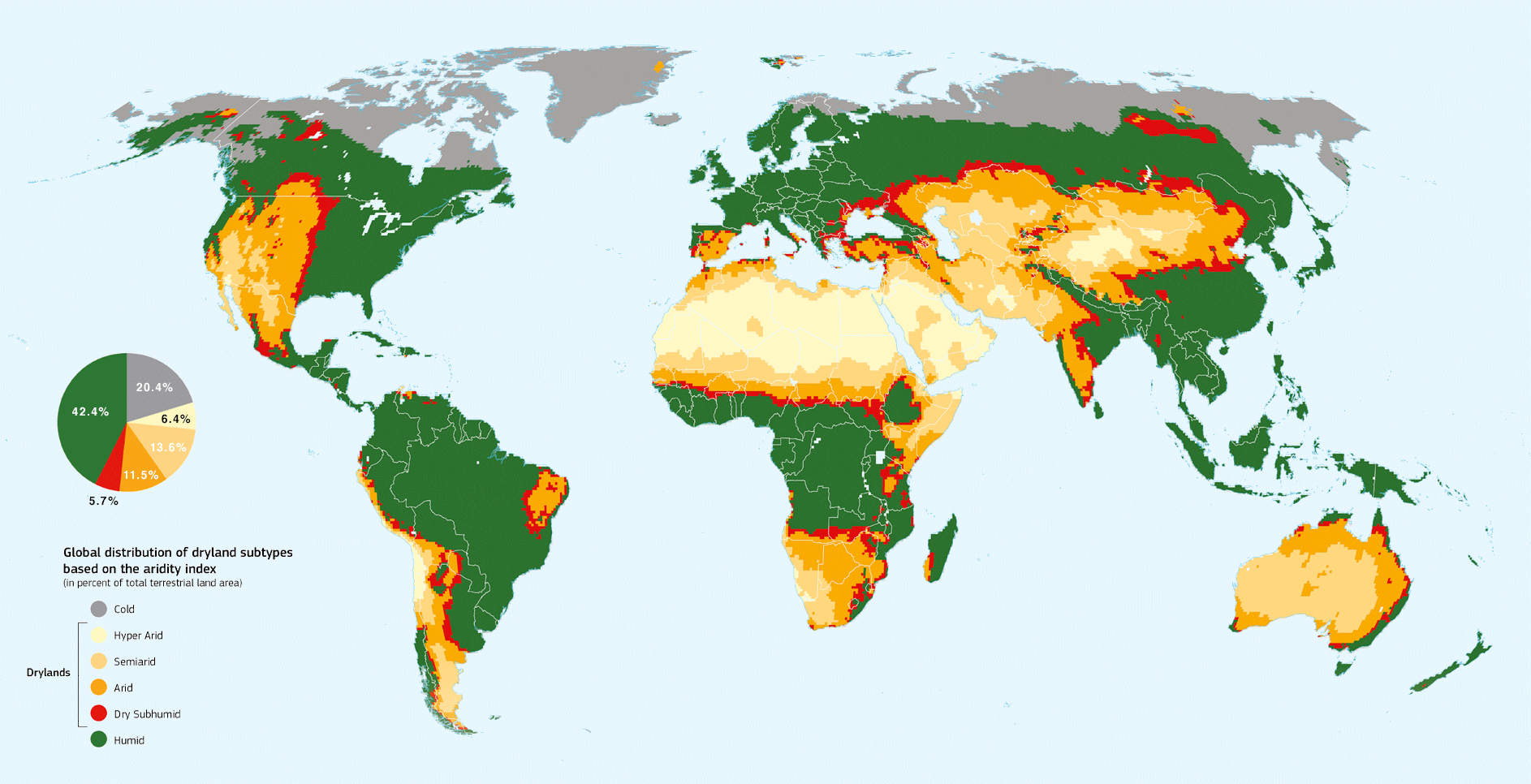
Galvin, Marc, and Ronald Jaubert. “The desertification myth?” Global Challenges, no. 6, November 2019. URL: https://globalchallenges.ch/issue/6/the-desertification-myth. DOI: https://doi.org/10.71609/iheid-0f8z-5p27.Dryland Subtypes and Non-dryland Types Based on the Aridity Index (AI)
Hyper-arid zones (AI < 0.03) are characterised by a nomadic pastoralism that is authentic and highly practiced. Precipitation – from 10 to 50 mm/year – is insufficient for agriculture except in natural or artificial environment. Interannual variability exceeds 40%. These zones cover the heart of the largest continental deserts (Central Sahara, Central Arabia) and coastal deserts of Peru/Chile and Namibia.
Arid zones (AI 0.03 to 0.20) are characterised by pastoralism and lack of agriculture except with irrigation. Native vegetation is generally rare, consisting of annual and perennial grasses and other herbaceous plants, as well as small, narrow-leaved or thorny trees. Precipitation – from 50 to 100 mm/year – is insufficient for agriculture. Interannual variability is between 30[ and 40%. The rains are limited to a few months a year. These zones cover the centres of continental deserts and the periphery of the most extensive continental deserts.
The semi-arid or Sahelian zones (AI 0.20 to 0.50) can support rainfed agriculture with more or less regular production levels. Sedentary breeding may sometimes occur. Native vegetation is represented by various species, such as grasses and grass-like plants, graminiform plants, steppes and small bushes, and shrubs and trees. Precipitation varies from 150 to 500 mm/year. Rainfed agriculture is possible but remains uncertain. The interannual variability oscillates between 30% and 40%.
The vegetation of dry or Sahelian-Sudanian subhumid zones (AI 0.50 to 0.65) is represented by deciduous trees, shrubs or highland savannahs with broadleaf leaves and deciduous forests. Precipitation varies from 500 to 800 mm spread over a rainy season of 6 months. Interannual variability is less than or equal to 20%.
Humid zones (AI ≥ 0.65) represent 42% of the total planet.
Cold areas cover 20,4% of the total planet. Their potential average evapotranspiration (PET) is less than 400 mm.
Research Office, The Graduate Institute, Geneva. Based on FAO.org.
Land degradation | Key terms
Like many common words, the word soil has several meanings. In its traditional meaning, soil is the natural medium for the growth of plants. Soil has also been defined as a natural body consisting of layers (soil horizons) that are composed of weathered mineral materials, organic material, air and water. Soil is the end product of the combined influence of climate, topography and organisms (flora, fauna and human) on parent materials (original rocks and minerals) over time. As a result, soil differs from its parent material in texture, structure, consistency, color, chemical, biological and physical characteristics. Soil is an essential component of land and eco-systems, which both are broader concepts encompassing vegetation, water and climate in the case of land, and in addition to those three aspects, also social and economic considerations in the case of ecosystems.
The word soil is also known as dirt, waste or earth.
Soil erosion is a common term that is often confused with soil degradation as a whole, but in fact refers only to absolute soil losses in terms of topsoil and nutrients. This is indeed the most visible effect of soil degradation, but it does not cover all of its aspects. Soil erosion is a natural process in mountainous areas, but is often made much worse by poor management practices.
Land degradation has a wider scope than both soil erosion and soil degradation in that it covers all negative changes in the capacity of the ecosystem to provide goods and services (including biological and water-related goods and services, and, in the vision of LADA – Land Degradation Assessment in Dryland – also land-related social and economic goods and services).
Desertification is another common term used for (a) land degradation in dryland areas and/or (b) the irreversible change of the land to such a state it can no longer be recovered for its original use.
Mitigation is intervention intended to reduce ongoing degradation. This comes in at a stage when degradation has already begun. The main aim is to halt further degradation and to start improving resources and their functions. Mitigation impacts tend to be noticeable in the short-to-medium term: this then provides a strong incentive for further efforts. The word mitigation is also sometimes used to describe the reductions of impacts of degradation.
Rehabilitation is required when the land is already degraded to such an extent that the original use is no longer possible and the land has become practically unproductive. Longer-term and often more costly investments are needed to show any impact.
Land degradation neutrality describes the state whereby the amount and quality of land resources, necessary to support ecosystem functions and services and enhance food security, remains stable or increases within specified temporal and spatial scales and ecosystems (source: UNCDD).
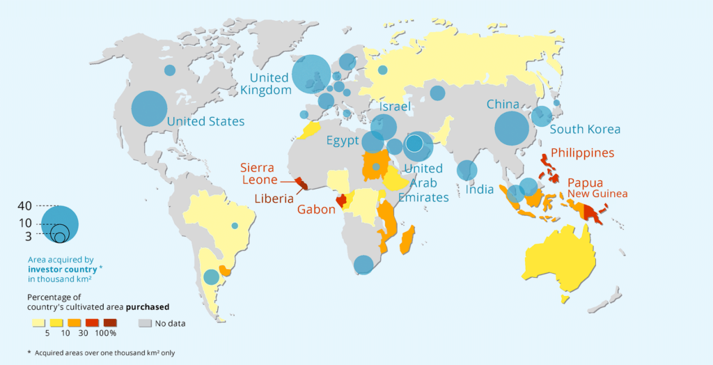
The term grabbing was adopted because of the lack of transparency in the set-up of land deals, their dubious legitimacy vis-à-vis communities who until then used these areas, and the dispossession the latter suffered once the deals were implemented. Estimates vary from 20 to 45 million hectares transacted between 2005 and 2010; the most recent estimates are around 30 million hectares in 78 countries. Actually, the calculation of grabbed areas has proven extremely challenging. Information is rarely disclosed given the controversial nature and the lack of legitimacy of those deals. Moreover, land grabs include not only transnational large-scale ones but also a broad range of national and local medium- and small-size land acquisitions that are hard to quantify.
Source (except for “land degradation neutrality” and “land grabbing”: © FAO, “FAO Soils Portal”, accessed 8 November 2019, http://www.fao.org/soils-portal/about/all-definitions/en/.
Interview with Professor Anne Saab
The Graduate Institute, Geneva.
Interview with Professor Filipe Calvão
Graduate Institute, Geneva.
Entretien avec le professeur Jacques Grinevald
Breakdown of the Global, Ice-Free Land Surface (130 million km2)
Source: IPCC, Climate Change and Land (August 2019), 4.