


Aerial Occupation and Aerial Forensics in Gaza
https://doi.org/10.71609/iheid-wrbr-p248Serving as Secretary of State for War and Air in the 1920s, Churchill espoused the use of air power to exercise colonial control from above, implemented in territories from Somaliland to India and Palestine to “…act as swift agents of government.”(Killingray 1984, p. 431). In a similar vein, Israel retained the ability to exercise territorial control in Gaza despite its formal, physical withdrawal in 2005, only now from above—aptly labelled an “airborne occupation” (Weizman 2013, p. 187; see also Adey, Whitehead, & Williams 2014; Darcy & Reynolds 2010). To exercise and enforce control from above, Israel relies on a sophisticated assortment of airborne technology, drones in particular. Not only are they cheaper to operate, silent, airborne for long periods, able to locate, track, and strike a variety of targets, but they also enable an “distant intimacy”—their operators remain invisible to potential adversaries and are shielded from reprisal (Williams 2015).To exercise and enforce control from above, Israel relies on a sophisticated assortment of airborne technology, drones in particular. In addition to drones, Israel carries out aerial attacks with helicopters and fighter jets, tanks and artillery, and on rare occasions from naval vessels (BBC 12.06.2015; Stahl 2010). This aerial ‘techno-human nexus’ or “kill-chain” (Gregory 2011, p. 196), capable of striking with lethal precision, is driven by a number of distinct rationales.
Rationale 1: Organisational Vulnerability
An overriding rationale for Israeli aerial attacks is targeted assassination—the elimination of Palestinian leaders from Hamas and other armed groups in an effort to weaken organisational capacity—derisively described as “mowing the grass” (Cohen et al. 2017, p. 1). Although the effectiveness of this drone-based strategy is disputed (Grieco & Hutto 2021; Hellmich 2012; Walsh 2013), repeated Israeli strikes are designed to produce vulnerability and dysfunction, effectively weakening Palestinian resistance (Cohen et al. 2017, p. 40; Weizman 2013).
Rationale 2: Territorial Control
Prior to its withdrawal from Gaza, the Israeli Defence Forces resorted to more traditional means of control on the ground, using checkpoints, walls, and night-time raids to create “buffer zones”, often levelling entire neighbourhoods inside Gaza (See Weizman 2013; Falah 2005). Aerial occupation, in marked contrast, has enabled Israel to exercise territorial control from above. Israel drops leaflets with the same devices used to drop bombs to evacuate buildings, neighbourhoods, or even entire zones (Cotter 2017). It also conducts airstrikes to destroy residential and commercial buildings in delineated areas, typically in close proximity to the border (Lyons 2012, p. 746; UNOSAT 2009, pp. 6-13). And it sprays crop-killing pesticides to enforce and expand military no-go areas or “buffer zones” (Forensic Architecture 2019), gradually transforming formerly agricultural zones into parched terrain that provides the Israeli military with clear sight to surveil and engage targets within Gaza (ibid).
Rationale 3: Weakening Collective Resolve
The 2009 UN Fact-Finding mission concluded its report by classifying the Israeli assault on Gaza as a “deliberately disproportionate attack designed to punish, humiliate and terrorise a civilian population (…) to force upon it an ever increasing sense of dependency and vulnerability” (Goldstone 2010, p. 407). In particular, the UN mission detected a pattern of systematic attacks against farms, food production, water supply and industrial facilities—including the only cement-packaging plant and the only operational flour mill in the Gaza Strip—that inflicted suffering on the civilian population (ibid, pp. 21-22). In keeping with this rationale, targeted strikes have destroyed thousands of homes, schools, hospitals, water, and electric supplies in an effort to collectively target, punish and demoralise Gaza’s residents (Sassen 2010). Added to this are the scores of Palestinian civilians killed both as a result of selective and indiscriminate violence (ibid, pp. 19-20).
Rationale 4: Weapons Testing
Gaza has been transformed into a site for Israel to experiment with new modes of urban and asymmetric warfare (Sassen 2010). Ground units of the IDF turned the urban structure of Gaza “inside out” by advancing inside and across buildings, perforating walls with high-tech explosives in an effort to counter conventional resistance tactics (Weizman 2006, p. 20). And as a major exporter of military technology to countries across the globe (Salman 2021), Israel has used Gaza as a site to test new weapons, such as teargas-dropping drones (Staff 31.03.2018), GPS-guided mortars, machine guns, mini robots, so-called “football cameras”, armed drones which can carry more than a ton of ammunition, electronic jamming devices, and more (Esposito 2009).
Aerial Forensics
Rather ironically, occupation from above is perhaps best documented from even higher altitudes, using aerial surveillance or satellite imagery. Rather ironically, occupation from above is perhaps best documented from even higher altitudes, using aerial surveillance or satellite imagery. The premise for such forensic work can be traced back to the basic principle developed by the forensics pioneer Locard, insofar as “every contact leaves a trace” (Horswell & Fowler 2004, p. 45). In other words, physical evidence is difficult to destroy in its entirety (Muehlberger 1954). Applying this insight to the case at hand, satellite imagery makes it possible to conduct detailed aerial forensics in Gaza. While for more than 20 years US legislation blurred publicly available satellite images of Israel and the occupied territories, a reversal of this policy has unveiled evidence of Israeli activities (Agha 2020). Such imagery supplies a view from above as well as a view into the past, given that the images are available in high resolution for extended time spans. Satellite imagery, typically available in resolutions that can range from 0.3m to 30m per pixel, is capable of producing geo-referenced data for end-users in real-time (Quinn et al. 2018).
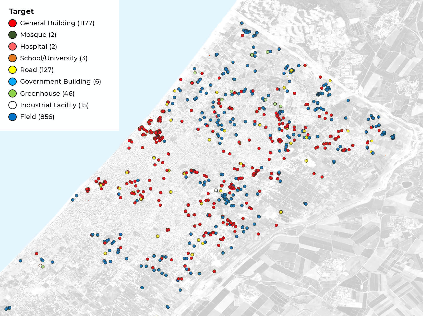
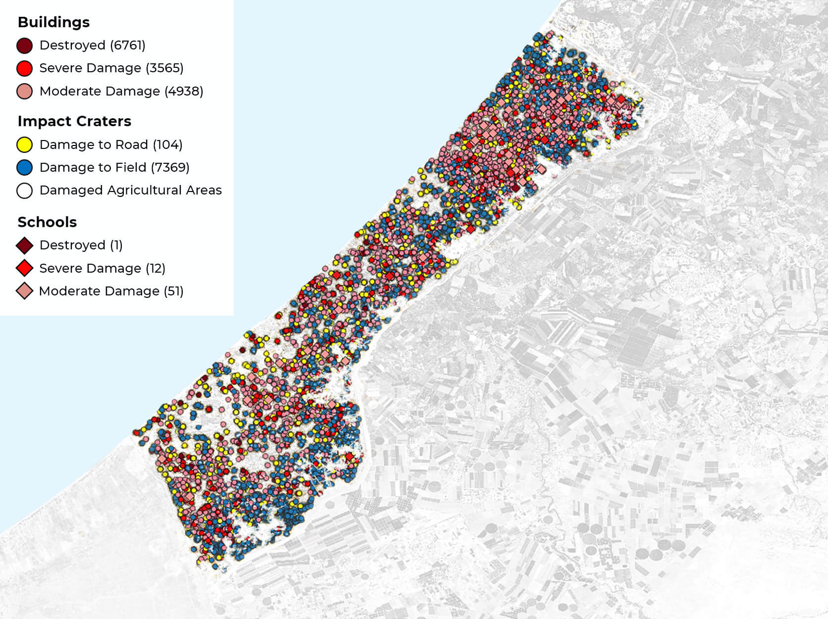
Figure 1 geo-codes targets bombed by Israel during the 50 days of the 2014 Gaza War, known as operation “Protective Edge”. Whereas the first Gaza war in 2008-09, dubbed “Operation Cast Lead”, was unprecedented in terms of the destruction caused (Goldstone 2010, pp. 405-06), 2014 went further still. In absolute numbers, 10,326 buildings were destroyed or severely damaged in 2014, compared to 2,852 in 2008-09. The death toll in 2014 reached 2,202, an estimated 63% of whom did not take part in hostilities, compared to 1,391 in 2008-09 (B’tselem 2022; UNOSAT 2014, pp. 22-23). The aerial visualisation is telling, insofar as few areas in Gaza were left unharmed. A visualisation of the more recent escalation in 2021, depicted in Figure 2, permits a finer-grained differentiation of the types of structures targeted. Seven years later, some patterns are clearly discernible.
Whereas agricultural sites were extensively targeted in 2014, a significant number of greenhouses and industrial facilities were also destroyed in 2021, in addition to mosques, hospitals and schools—lending support to the notion of deliberate economic subjugation and weakening of collective resolve in Gaza (Alimahomed‐Wilson & Potiker 2017; Roy 1987).
Conclusion
The Gaza strip spans some 365 km², less than half the size of New York, populated by more than 2.16 million people (Statistics 2022; UN Habitat 2014). Modelling the expansion of built-up areas in Gaza using Landsat satellite data and a CA-Markov model to detect changes, Attaallah (2018) suggests that close to one-half of Gaza Strip will be built-up in less than fifteen years. As Israel conducts its occupation from above, aerial forensics effectively reveal the underlying rationales at play, designed to increase vulnerability, exercise territorial control, weaken resolve, and conduct weapons tests. As we obtain access to more granular, repeated waves of satellite data, we expect to conduct detailed longitudinal analysis of the occupation, its underlying rationales, and outcomes.
Electronic reference
Hellinger, Joshua, and Ravi Bhavnani. “Aerial Occupation and Aerial Forensics in Gaza.” Global Challenges, Special Issue no. 2, March 2023. URL: https://globalchallenges.ch/issue/special_2/aerial-occupation-and-aerial-forensics-in-gaza. DOI: https://doi.org/10.71609/iheid-wrbr-p248.The editors of this issue are grateful to Gopalan Balachandran, Christiana Parreira, Michelle Weitzel, and the editorial team at the Geneva Graduate Institute for comments on the essays.
Figure 2 : Visualization of UNOSAT damage assessment in Northern Gaza from May 20 and 28, 20 21 on Sentinel II imagery
ESA, 2023; UNOSAT, 05.06.2021
Figure 1 : Visualization of 2014 UNOSAT damage assessment on Sentinel II imagery
ESA, 2023; UNOSAT, 02.10.2014